History of Teikoku-Shoin
| Date | History | Major Publications | ||
|---|---|---|---|---|
| 1917(Taisho 6) |
|
|||
| 1926(Taisho 15) | In July, Teikoku-Shoin was organized as a stock company and its office building was built at 1-3 Nishikanda, Kanda-ku. | The sales of our textbooks and atlases for lower secondary school students under the old system of education were at a record high. | ||
| 1934(Showa 9) |
|
|||
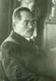
| 1938(Showa 13) | The founder Susabio Moriya died. | Susabio Moriya produced 198 textbooks in total from 1921 (Taisho 10) to 1938 (Showa 13). | ||
| 1942(Showa 17) | Due to the Daily Essentials Control Ordinance and with the Second World War intensifying, Teikoku-Shoin Co., Ltd. was united into the newly established Lower Secondary School Textbooks Co., Ltd. | |||
| 1946(Showa 21) | The Lower Secondary School Textbooks Co., Ltd. dissolved. The company rented a temporary office in Nihonbashi, Chuo-ku, for reconstruction after the war. | Textbook companies were permitted to freely publish. The company restarted publishing atlases, such as [New Atlas of Japan]. | ||
| 1954(Showa 29) | Published an atlas, Shinsho Koto Chizu [New Detailed Atlas for upper secondary school students]and a geography textbook for upper secondary school students for the first time. | |||
| 1957(Showa 32) | The head office was relocated to the present location in Kanda-Jimbocho. | Published Kihan Nihon Daichizu [Standard Atlas of Japan], the first full-fledged atlas after the war, and it experienced great popularity. | ||
| 1959(Showa 34) | Chugakko Shakaika Chizucho[Atlas for Lower Secondary School Students] was adopted across Japan and had a large share of the market. | |||
| 1961(Showa 36) | Started attending the Frankfurt Book Fair. | |||
| 1963(Showa 38) | (Textbooks for primary school pupils started to be distributed for free.) | |||
| 1967(Showa 42) | Published our second atlas for upper secondary school students, Hyojun Koto Chizu [Standard Atlas for Upper Secondary School Students]. | |||
| 1969(Showa 44) | Published Transparency, new audiovisual material, to enter into the educational material market. | |||
| 1970(Showa 45) | Started to produce JAL Route Map. | |||
| 1973(Showa 48) | Won the largest number of adoptions of a Geography textbook for upper secondary school students. Started to produce ANA Route Map. | |||
| 1975(Showa 50) | Enjoyed popularity of Wall Maps for lower secondary schools because of their lightness and toughness. | |||
| 1977(Showa 52) | Entered into alliances with Geography textbook publishers in every country to publish a translated version of the textbook, Translated version of World Geography Textbook Series, in 30 volumes over the next four years. Proved greatly popular. | |||
| 1980(Showa 55) | Started to produce globes. | |||
| 1981(Showa 56) | Published supplementary material, Illustrated History Atlas of World, for upper secondary school students and achieved remarkable success. | |||
| 1982(Showa 57) | Teikoku-Shoin Co., Ltd. founded the Moriya Foundation to support students from other Asian countries. | |||
| 1983(Showa 58) | To increase efficiency of shipments, Teikoku-Shoin Co., Ltd. built a warehouse in Kawagoe-shi. | Published 33 volumes of Complete Translation of World History Textbooks and received the Japan Translation Publishing Culture Award. | ||
| 1987(Showa 62) | Due to age deterioration, the head office building was relocated into a temporary office in Ichibancho, Chiyoda-ku, during the reconstruction. | Published Places in the World, which was the first landscape orientation textbook. Most of it was adopted for a Geography textbook for upper secondary school students. | ||
| 1988(Showa 63) | The new head office building was completed in November. In December, the company was relocated to the new building. | |||
| 1989(Heisei 1) | In January, Teikoku-Shoin Co., Ltd. started operations at the new head office building and introduced an automated cartographic system. | |||
| 1990(Heisei 2) | The Teikoku-Shoin Map Compiling building was completed in Takashimadaira, Itabashi-ku, and introduced a computer-aided cartographic system. | Restarted publishing a History textbook for lower secondary school students, which had been suspended in 1981. | ||
| 1993(Heisei 5) | Restarted publishing a Civics textbook for lower secondary school students, which involved publishing all three social studies textbooks for lower secondary school students. | |||
| 1995(Heisei 7) | Published Standard Atlas: Modern World and Its Historical Background, which could be used in World History classes, and received attention not only from schools but also from general readers. (This was renamed Geo-History Atlas for Upper Secondary School Students.) | |||
| 1999(Heisei 11) | Published an atlas for general readers, Historical Stages: Atlas of Japan. This atlas had the innovative feature of historical elements plotted on maps and became the bestselling atlas of the year. | |||
| 2002(Heisei 14) | (The New National Curriculum based on the new course of study for primary and lower secondary schools took effect.) | Adoption in primary and lower secondary schools dramatically increased. In particular, History for Lower Secondary School Students: Steps of Japan and Movements of World sold very well. | ||
| 2003(Heisei 15) | Published the New Illustrated World History: Tapestry for upper secondary school students. Also published Standard Atlas for Upper Secondary School Students: Reading Modern Society through Atlas, which can be used in Modern Society classes. Both of them were highly valued. |
|||
| 2004(Heisei 16) | Completely revised Atlas of the World: this makes you feel like travelling by suggesting travelling styles that matched a new era. Published Movements in the Showa era through Atlas, a reprint atlas. This was highly evaluated in book reviews and feature articles. |
|||
| 2005(Heisei 17) | Our publications for lower secondary schools were widely adopted. The increase in four social studies publications received top marks from the textbook publishers. | |||
| 2006(Heisei 18) | Completely revised Atlas of Japan: this makes you feel like traveling.Attractive maps gained stronger reputations and were rediscovered throughout Japan. | |||
| 2010(Heisei 22) | Publishied Matsumoto Seicho Atlas. Its innovatite design drew keen attention. | |||
| 2012(Heisei 24) | Publishied Teikoku-Shoin Geography series: Countries in the World vol. 1-10 and received the 14th School Library Publication Award. | |||
| 2013(Heisei 25) | Published Teikoku-Shoin Geography series: Japan as it is vol.1-9 and received the 15th School Library Publication Award. Published Song Atlas. The idea of linking songs with maps was well-received. |
|||
| 2014(Heisei 26) | Published Illustrated History of Japan, to enter into the Japanese History material market. Published Learn from Illustrations and Maps! Industires and Nature of Japan series for primary school libraries. |
|||
| 2017(Heisei 29) | Marked 100th anniversary of the founding of Teikoku-Shoin. | Published Understand and Prepare for Disasters and Preventions and received the 19th School Library Publication Award. | ||